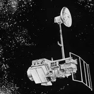
Landsat 5
Orbiter · Directed · Agency-led · Launched on March 1, 1984 · Completed · LCC: $275M/$1.4B (2025 $) · Wikipedia
| Tracked publications | 996 |
|---|---|
| Citations | 31,071 |
| Citation indices | |
|---|---|
| h-index | 80 |
| g-index | 140 |
| m-index | 1.9 |
| tori | 322 |
| riq | 427 |
Publications and citations by year (lifetime)
Publications per yearCumulative citations
Institutional contributions (lifetime)
Tracked publications over the lifetime (996)
An assessment of the effectiveness of a random forest classifier for land-cover classification
1,842
Land surface temperature retrieval from LANDSAT TM 5
1,577
Revised Landsat-5 TM Radiometric Calibration Procedures and Postcalibration Dynamic Ranges
613
The global Landsat archive: Status, consolidation, and direction
593
The Global Mangrove Watch—A New 2010 Global Baseline of Mangrove Extent
506
-
467
Landsat continuity: Issues and opportunities for land cover monitoring
415
Landsat: Building a strong future
339
Fmask 4.0: Improved cloud and cloud shadow detection in Landsats 4-8 and Sentinel-2 imagery
319
-
303
-
269
-
255
Retrieval of wet snow by means of multitemporal SAR data
242
Landsat Sensor Performance: History and Current Status
241
-
228
Evaluation of Landsat and MODIS data fusion products for analysis of dryland forest phenology
228
Forty-year calibrated record of earth-reflected radiance from Landsat: A review
206
Evaluation of the Landsat-5 TM and Landsat-7 ETM + surface reflectance products
199
Estimating the leaf area index of North Central Wisconsin forests using the landsat thematic mapper
191
-
184
How we found these papers
We searched NASA’s Science Explorer (SciX) for peer-reviewed articles naming Landsat 5 in the title, abstract or keywords; standard filters drop articles that are not peer-reviewed and magazine pieces.
((=abs:"Landsat-5" OR =abs:"Landsat 4-5" OR =abs:"Landsats 5" OR =abs:"Landsats 4 5" OR =abs:"Landsat TM5" OR =abs:"Landsat TM 5" OR =abs:"Thematic Mapper 5" OR =abs:"Thematic Mapper TM 5" OR =abs:"Landsat satellites 5" OR =abs:"Landsat satellite 5" OR =abs:"Landsat missions 5" OR =abs:"Landsat series 5" OR =abs:"Landsat 2 5" OR =abs:"Landsat 7 5" OR =abs:"Landsat 8 5" OR =abs:"Landsat 1 5" OR =abs:"Landsat 4 7" OR =abs:"Landsat 4 8" OR =abs:"Landsats 4 8" OR =abs:"Landsat 4 9")) AND property:refereed AND doctype:article AND pubdate:[1984-04 TO 2040-01] AND NOT bibstem:("A&R" OR "ACPD" OR "AIASJ" OR "AMTD" OR "AeAm" OR "AirSp" OR "AsNow" OR "AsUAI" OR "AvWST" OR "BGD" OR "C&E" OR "C&T" OR "CAPJ" OR "CliPD" OR "E&S" OR "ENews" OR "ESDD" OR "ESSDD" OR "ESuDD" OR "GID" OR "GMDD" OR "GeCAS" OR "HESSD" OR "IrAJ" OR "JCos" OR "JRASC" OR "LAstr" OR "MNSSA" OR "Met" OR "NHESD" OR "NPGD" OR "NewSc" OR "OcScD" OR "Orion" OR "PhT" OR "PhTea" OR "PhuZ" OR "PhyOJ" OR "PhyW" OR "PlR" OR "SOILD" OR "SciAm" OR "SpFl" OR "TCD" OR "ZemVs")
Added after review
- Thematic Mapper Data Used for Rangeland Management in Rough Fescue Grasslands in Western Canada Mission's first published science result: Thematic Mapper imagery used to map rangeland condition in western Canada.
Removed after review
- A video system capable of simulating Landsat TM 5, 4, 3 imagery "TM 5, 4, 3" refers to Thematic Mapper bands; does not name Landsat 5.
- Spectral reflectance measurements in the genus Sphagnum "Thematic Mapper 5/4" refers to a band ratio; does not name Landsat 5.
- Impacts of urbanization on soil organic carbon stocks in the northeast coastal agricultural areas of China "Landsat TM5" refers to Thematic Mapper band 5; does not name Landsat 5.
- Gap-filling of land surface temperature in arid regions by combining Landsat 8 and 9 imageries The text "Landsat 8 and 5.4 °C" matches; does not name Landsat 5.