Earth Science

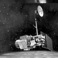
Landsat 4

Orbiter · Directed · Agency-led · Launched on July 16, 1982 · Completed · LCC: $275M/$1.4B (2025 $)Life-cycle cost: NASA’s reported cost to build, launch, and operate a mission through its prime mission, plus documented partner contributions, in 2025 dollars. Extended missions are not included. Methods · Wikipedia

Scope Active Mission WindowActivePapers published from the first full month after science operations begin through two years after the mission ends. Citations are counted through the third calendar year after each paper appears. For Landsat 4, papers published February 1, 1983 to July 1, 2003. Methods LifetimeLifetimeEvery tracked publication to date, with every citation to date. For Landsat 4, papers published from 1983 to November 3, 2026. Methods
Tracked publicationsTracked publications: peer-reviewed papers we found that name the mission or its instruments in their titles, abstracts, or keywords. Papers that used the data without naming it are missed. Methods188
CitationsCitations: every citation these publications have drawn to date. Older missions have had longer to collect them. Methods6,712
Citation indices
h-indexh-index: the largest h such that h papers have at least h citations each. It only grows with time, so older missions score higher. Methods36
g-indexg-index: the largest g for which the g most-cited papers together hold at least g² citations. Like the h-index, but it lets the most-cited papers count for more. Methods79
m-indexm-index: a mission’s h-index divided by the years since its first peer-reviewed paper. It falls every 1 January even when nothing else changes; the figure shown is as of November 3, 2026. It also discounts the long operating life that larger missions paid for. Methods0.8
toritori (total research impact, from SciX): for every paper citing one of the mission’s papers, 1 divided by the citing paper’s reference count times the cited paper’s author count, summed, with self-citations removed. It favors citations from papers with short reference lists and from outside the mission’s own authors. Computed over the tracked citation graph, which can be slightly incomplete. Always over every tracked publication to date, whichever scope is chosen. Methods102
riqriq (research impact quotient): 1,000 times the square root of tori, divided by the years since the mission’s first paper. A rate, not a total, so it does not keep growing with age the way the h-index and tori do. Like tori, always over every tracked publication to date. Methods230

Publications and citations by year (lifetime)

Publications per yearCumulative citations

Institutional contributions (lifetime)The institutions SciX lists for each paper’s authors, as printed on the paper, located through the Research Organization Registry. A square counts a paper once, however many of its authors worked there. Methods

Loading the map…

Tracked publications over the lifetime (188)

All publications CSV · JSON

  1. Improvement and expansion of the Fmask algorithm: cloud, cloud shadow, and snow detection for Landsats 4-7, 8, and Sentinel 2 images

    Zhu, Zhe, 2015, RSEnv

    1,232 lifetime citations

  2. Revised Landsat-5 TM Radiometric Calibration Procedures and Postcalibration Dynamic Ranges

    Chander, Gyanesh, 2003, ITGRS

    613 lifetime citations

  3. Revision of the Single-Channel Algorithm for Land Surface Temperature Retrieval from Landsat Thermal-Infrared Data

    Jiménez-Muñoz, Juan C., 2009, ITGRS

    467 lifetime citations

  4. Fmask 4.0: Improved cloud and cloud shadow detection in Landsats 4-8 and Sentinel-2 imagery

    Qiu, Shi, 2019, RSEnv

    319 lifetime citations

  5. Landsat Sensor Performance: History and Current Status

    Markham, Brian L., 2004, ITGRS

    241 lifetime citations

  6. Forty-year calibrated record of earth-reflected radiance from Landsat: A review

    Markham, Brian L., 2012, RSEnv

    206 lifetime citations

  7. Spectral characterization of the Landsat Thematic Mapper sensors

    Markham, B. L., 1985, IJRS

    183 lifetime citations

  8. Optimizing selection of training and auxiliary data for operational land cover classification for the LCMAP initiative

    Zhu, Zhe, 2016, JPRS

    164 lifetime citations

  9. Glacier Remote Sensing Using Sentinel-2. Part II: Mapping Glacier Extents and Surface Facies, and Comparison to Landsat 8

    Paul, Frank, 2016, RemS

    150 lifetime citations

  10. Assessment of land use land cover changes and its impact on variations of land surface temperature in Asansol-Durgapur Development Region

    Choudhury, Deblina, 2019, EJRSS

    134 lifetime citations

  11. An automatic method for screening clouds and cloud shadows in optical satellite image time series in cloudy regions

    Zhu, Xiaolin, 2018, RSEnv

    130 lifetime citations

  12. Effects of Landsat 5 Thematic Mapper and Landsat 7 Enhanced Thematic Mapper Plus radiometric and geometric calibrations and corrections on landscape characterization

    Vogelmann, James E., 2001, RSEnv

    126 lifetime citations

  13. Snow Reflectance from LANDSAT-4 Thematic Mapper

    Dozier, Jeff, 1984, ITGRS

    121 lifetime citations

  14. Improving Fmask cloud and cloud shadow detection in mountainous area for Landsats 4-8 images

    Qiu, Shi, 2017, RSEnv

    116 lifetime citations

  15. Assessing and predicting land use/land cover, land surface temperature and urban thermal field variance index using Landsat imagery for Dhaka Metropolitan area

    Faisal, Abdullah-Al-, 2021, EnvCh

    110 lifetime citations

  16. Suspended Sediment Concentration Estimation from Landsat Imagery along the Lower Missouri and Middle Mississippi Rivers Using an Extreme Learning Machine

    Peterson, Kyle T., 2018, RemS

    104 lifetime citations

  17. Predicting the impacts of land use/land cover changes on seasonal urban thermal characteristics using machine learning algorithms

    Kafy, Abdulla-Al, 2022, BuEnv

    92 lifetime citations

  18. Radiometric properties of U.S. processed landsat MSS data

    Markham, Brian L., 1987, RSEnv

    84 lifetime citations

  19. Landslide Susceptibility Mapping Using Logistic Regression Analysis along the Jinsha River and Its Tributaries Close to Derong and Deqin County, Southwestern China

    Sun, Xiaohui, 2018, IJGI

    81 lifetime citations

  20. Landsat-5 TM and Landsat-7 ETM+ Absolute Radiometric Calibration Using the Reflectance-Based Method

    Thome, Kurtis J., 2004, ITGRS

    73 lifetime citations

How we found these papers

We searched NASA’s Science Explorer (SciX) for peer-reviewed articles naming Landsat 4 in the title, abstract or keywords; standard filters drop articles that are not peer-reviewed and magazine pieces.

((=abs:"Landsat-4" OR =abs:"Landsat 4-5" OR =abs:"Landsats 4" OR =abs:"Landsat TM 4 5" OR =abs:"Landsat missions 4" OR =abs:"Landsat 1 4" OR =abs:"Landsat 1 5" OR =abs:"Landsats 1 5" OR =abs:"Landsat 1 8" OR =abs:"Landsat 1 9" OR =abs:"Landsat-D")) AND property:refereed AND doctype:article AND pubdate:[1983-02 TO 2040-01] AND NOT bibstem:("A&R" OR "ACPD" OR "AIASJ" OR "AMTD" OR "AeAm" OR "AirSp" OR "AsNow" OR "AsUAI" OR "AvWST" OR "BGD" OR "C&E" OR "C&T" OR "CAPJ" OR "CliPD" OR "E&S" OR "ENews" OR "ESDD" OR "ESSDD" OR "ESuDD" OR "GID" OR "GMDD" OR "GeCAS" OR "HESSD" OR "IrAJ" OR "JCos" OR "JRASC" OR "LAstr" OR "MNSSA" OR "Met" OR "NHESD" OR "NPGD" OR "NewSc" OR "OcScD" OR "Orion" OR "PhT" OR "PhTea" OR "PhuZ" OR "PhyOJ" OR "PhyW" OR "PlR" OR "SOILD" OR "SciAm" OR "SpFl" OR "TCD" OR "ZemVs")
Open in SciX

Added after review (6)

  1. Sensor data for forest policy information Discusses the Thematic Mapper before Landsat 5's launch, when only Landsat 4 carried one. Decision 🤖
  2. An analysis of thematic mapper simulator data for urban environments Thematic Mapper study published before Landsat 5's launch, when only Landsat 4 carried one. Decision 🤖
  3. Leaf water stress detection utilizing thematic mapper bands 3, 4 and 5 in soybean plants Thematic Mapper study published before Landsat 5's launch, when only Landsat 4 carried one. Decision 🤖
  4. Relation of Agronomic and Multispectral Reflectance Characteristics of Spring Wheat Canopies¹ Thematic Mapper study published before Landsat 5's launch, when only Landsat 4 carried one. Decision 🤖
  5. Variation in Alluvial-Derived Soils as Measured by Landsat Thematic Mapper Analyzes Thematic Mapper data acquired before Landsat 5's launch, so from Landsat 4. Decision 🤖
  6. Comparison of simulated thematic mapper data and multispectral scanner data Thematic Mapper study published before Landsat 5's launch, when only Landsat 4 carried one. Decision 🤖

Removed after review (2)

  1. The landsat sensors: Eosat's plans for landsats 6 and 7 Describes the Thematic Mappers planned for Landsats 6 and 7; Landsat 4 is design heritage. Decision 🤖
  2. Use of rice response characteristics in area estimation by LANDSAT/TM and MOS-1 satellites data "TM 4 and 5" refers to Thematic Mapper bands; does not name Landsat 4. Decision 🤖