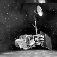
Landsat 4
315 tracked publications and 10,556 citations from 1983–2026. Launched 1982. Life-cycle cost: $1.4B in 2025 dollars. Active Mission Window February 1, 1983 to July 1, 2003: 80 publications, 1.2 top-10% credit.
Orbiter · h-index 46 · 24 papers with 100+ citations · prime mission ended 1985
Lifetime
Key measures
| Active Mission Window · papers February 1, 1983 to July 1, 2003 | |
|---|---|
| Tracked publications | 80 |
| Citations | 225 |
| Mean citations per publication | 2.8 |
| Median citations per publication | 1 |
| Uncited publications | 34 (43%) |
| Top-10% credit | 1.2 |
| Top-1% credit | 0 |
| Lifetime indices · every tracked publication to date, in any scope | |
|---|---|
| h-index | 46 |
| g-index | 96 |
| m-index, as of October 4, 2026 | 1.0 |
| tori | 129 |
| riq | 258 |
Tracked publications
-
1,194
Revised Landsat-5 TM Radiometric Calibration Procedures and Postcalibration Dynamic Ranges
610
Google Earth Engine Open-Source Code for Land Surface Temperature Estimation from the Landsat Series
457
-
450
-
344
Analysis Ready Data: Enabling Analysis of the Landsat Archive
325
Fmask 4.0: Improved cloud and cloud shadow detection in Landsats 4-8 and Sentinel-2 imagery
306
-
256
Landsat Sensor Performance: History and Current Status
237
Forty-year calibrated record of earth-reflected radiance from Landsat: A review
200
-
190
Spectral characterization of the Landsat Thematic Mapper sensors
183
-
176
-
161
-
149
-
132
-
132
-
127
-
124
Snow Reflectance from LANDSAT-4 Thematic Mapper
120
How we found these papers
We searched NASA’s Astrophysics Data System (ADS) for peer-reviewed articles naming Landsat 4 in the title, abstract or keywords; standard filters drop articles that are not peer-reviewed and magazine pieces. SciX is ADS’s current interface.
((=abs:"Landsat-4" OR =abs:"Landsat 4-5" OR =abs:"Landsats 4" OR =abs:"Landsat TM 4 5" OR =abs:"Landsat missions 4" OR =abs:"Landsat 1 4" OR =abs:"Landsat 1 5" OR =abs:"Landsats 1 5" OR =abs:"Landsat 1 8" OR =abs:"Landsat 1 9" OR =abs:"Landsat-D")) AND property:refereed AND doctype:article AND pubdate:[1983-02 TO 2040-01] AND NOT bibstem:("A&R" OR "AIASJ" OR "AeAm" OR "AirSp" OR "AsNow" OR "AsUAI" OR "AvWST" OR "C&E" OR "C&T" OR "CAPJ" OR "E&S" OR "ENews" OR "IrAJ" OR "JCos" OR "JRASC" OR "LAstr" OR "MNSSA" OR "Met" OR "NewSc" OR "Orion" OR "PhT" OR "PhTea" OR "PhuZ" OR "PhyOJ" OR "PhyW" OR "PlR" OR "SciAm" OR "SpFl" OR "ZemVs")
Added after review
- Sensor data for forest policy information Discusses the Thematic Mapper before Landsat 5's launch, when only Landsat 4 carried one.
- An analysis of thematic mapper simulator data for urban environments Thematic Mapper study published before Landsat 5's launch, when only Landsat 4 carried one.
- Leaf water stress detection utilizing thematic mapper bands 3, 4 and 5 in soybean plants Thematic Mapper study published before Landsat 5's launch, when only Landsat 4 carried one.
- Relation of Agronomic and Multispectral Reflectance Characteristics of Spring Wheat Canopies¹ Thematic Mapper study published before Landsat 5's launch, when only Landsat 4 carried one.
- Variation in Alluvial-Derived Soils as Measured by Landsat Thematic Mapper Analyzes Thematic Mapper data acquired before Landsat 5's launch, so from Landsat 4.
- Comparison of simulated thematic mapper data and multispectral scanner data Thematic Mapper study published before Landsat 5's launch, when only Landsat 4 carried one.
Removed after review
- Evaluation of four image fusion NDVI products against in-situ spectral-measurements over a heterogeneous rice paddy landscape Matches only the text "Landsat (-4%)"; does not name Landsat 4.
- Subsurface Imaging by RADARSAT: Comparison with Landsat TM Data and Implications for Ground Water in the Selima Area, Northwestern Sudan French text "Landsat d'une" matches Landsat-D; does not name Landsat 4.
- The landsat sensors: Eosat's plans for landsats 6 and 7 Describes the Thematic Mappers planned for Landsats 6 and 7; Landsat 4 is design heritage.
- Use of rice response characteristics in area estimation by LANDSAT/TM and MOS-1 satellites data "TM 4 and 5" refers to Thematic Mapper bands; does not name Landsat 4.
- Landsat-7 Enhanced Thematic Mapper Plus Radiometric Calibration Pre-launch calibration plan for Landsat 7's ETM+; Landsat 4 appears as design heritage.